Multiple Video and Sensor Data Convergence for CJADC2
 Multi Domain Sensors and Video on a Single Display
JUPITER, FL, USA, December 27, 2023 /EINPresswire.com/ — .
In a world where drone technology has been advancing at an unprecedented pace, the AGIS team of engineers and software developers have embarked on a mission to revolutionize the way drone operations were managed. Their goal was to create an enhanced capability that would allow for the seamless display of multiple videos from multiple drones, integrating all the video information along with seismic, magnetic, satellite and other intelligence inputs into a single command and control display.
The AGIS team has worked with the U.S. government and privately sourced funds, combining their expertise in drone technology, video processing, and user interface design. After months of research, development, and technical initiative, AGIS is finally able to unveil their groundbreaking creation.
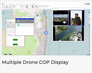
This new capability is possibly a game-changer in the world of drone operations, as this information gets fully absorbed and integrated into a digital common operating picture (COP). Command gets to have a comprehensive and real-time view of friendly and hostile troop locations, sensor data and multiple drones in action, all on a single display. Gone are the days of toggling between different screens or struggling to keep track of multiple video feeds. With this leap ahead innovation, users and command can now effortlessly send data to the drone operators and monitor and analyze video feeds from multiple drones simultaneously.
The AGIS COP display is an easy-to-use and intuitive interface that allows users to seamlessly switch between different drone feeds in a few clicks. The display accommodates feeds from various types of sensors, users, and drones, whether they were aerial, ground-based, surface, or even underwater.
The inclusion of real-time data links such as CoT, Link-16, OTH-Gold, JVMF, NATO, and sensor data further enhances the COP display’s capabilities. Command and operators can access vital information such as UAS location, Operators’ location, bearing, range, altitude, speed, and sensor readings, all in real-time. This data provides valuable context and intelligence, allowing for a clearer understanding of the operational environment and enables operators to identify patterns, detect anomalies, and make informed decisions based on the most up-to-date information available.
The integration of various ground, magnetic, seismic, radar sensors and video information into a single C5ISR display brings about a new level of situational awareness and decision-making capabilities. Users can now observe the entire operation from a bird’s-eye view or zoom in on specific areas of interest with ease. This holistic inclusion and integration of the drones’ missions enables more efficient coordination and enhances the overall effectiveness of the operation.
For a moment, let us consider a scenario where a team of search & rescue drones was deployed to locate a missing soldier in a vast and treacherous mountain range. In the past, managing multiple drones and their video feeds would have been a logistical and technical challenge. But with a new capability with AGIS C5ISR software, the command-and-control center can integrate multiple video feeds and other related information into a hub of information and mission control.
As multiple drones scour the mountainside, their video feeds can be seamlessly streamed on to the AGIS C5ISR command and control displays, which can be either on mobile platforms or fixed. The search & rescue team can monitor each of the multiple drones’ progress, heading, location, identify potential hazards, and make informed decisions in real-time. The integration of video information with other ground based sensors such as one accomplished by AGIS with Iridium and with McQ sensors (Video: <https://www.agisinc.com/videos/IRD-AGIS-MCQ.mp4>) into a single display allows for the coordination of multi domain efforts effectively in the spirit of CJADC2.
Command gets to have a comprehensive and real-time view of sensors and multiple drones in action, all on a single display.”
— Malcolm K. Beyer, Jr.
Overall, the new C5ISR capability to display multiple drone videos on a COP display, along with real-time data link and sensor data, on a single pane of glass represents a significant advancement in an expanded use of command-and-control systems. It empowers operators with a comprehensive and real-time understanding of the operational environment, enhancing situational awareness, aiding decision-making, and ultimately, mission success.
In conclusion, the new capability to display multiple videos from multiple drones and sensor information into a single command and control display, is a groundbreaking innovation that transforms the way operations are observed and managed. It provides users with a comprehensive COP view, enhanced situational awareness, and streamlined decision-making processes. This technological marvel opens a world of possibilities and paves the way for a future where drones play an even more significant role in both military and commercial applications.
Malcolm K. Beyer, Jr.
Advanced Ground Information Systems (AGIS), Inc.
+1 561-744-3213
beyerm@agisinc.com
Post a comment
You must be logged in to post a comment.