AGIS Groundbreaking CJADC2-COP Software for Global Integration of Space, Marine & Undersea Sensor Data at CT23 Exercises
 JUPITER, FL, USA, September 25, 2023 /EINPresswire.com/ —
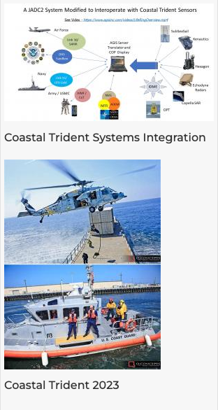
AGIS, a leader in advanced command and control (C5ISR) software solutions, recently successfully concluded an integration of marine and undersea sensor data from multiple manufacturers into its extraordinary Common Operating Picture (COP) software, while interfacing with the Department of Homeland Security (DHS) Integrated Multi Domain Enterprise (IMDE) program. This breakthrough achievement was demonstrated during a government-sponsored ANTX-Coastal Trident 2023 live exercise off the coast of California last month.
The COP software developed by AGIS provides a comprehensive and real-time visualization of mission-critical data, enabling enhanced command and control capabilities for military, defense, and government agencies. During the live exercise, a global common operating picture was successfully generated, displaying real-time information from a network of sensors positioned across the marine and undersea environments.
The AGIS software effectively ingested sensor data from multiple manufacturers, facilitating a holistic view of the operational area. This integration enabled immediate identification of potential threats, enhanced situational understanding, and improved response times. By seamlessly integrating marine and undersea sensor data from various manufacturers, the COP software allows for unparalleled situational awareness and decision-making capabilities.
The scope of this achievement in integrating marine and undersea sensor data on a global scale cannot be understated. The COP software’s ability to process and visualize complex data from disparate sources in a unified manner demonstrates how it has raised the standard for operational efficiency and effectiveness. Together with other intelligence gathering tools, this technology offers an invaluable advantage to decision-makers in the defense, military, and government sectors.
The successful integration of marine and undersea sensor data reaffirms our commitment to developing innovative solutions that address the evolving needs of our customers.”
— Malcolm K. Beyer, Jr.
AGIS is proud to be at the forefront of digital integration and interoperability in the command and control domain. The successful integration of marine and undersea sensor data reaffirms our commitment to developing innovative solutions that address the evolving needs of our customers.
The COP software’s global scope has the potential to revolutionize how command and control systems operate, enabling seamless collaboration and information sharing across different agencies and geographies. This development signifies a significant step toward achieving a truly interconnected and unified near real-time operating information system in missions that involve both terrestrial and undersea sensor environments.
About AGIS:
AGIS is a small non-traditional business that is a leading provider of cutting-edge command and control software solutions. With a focus on innovation and customer-centricity, AGIS develops advanced technologies that empower defense, military, and government agencies to enhance operational efficiency, situational awareness, and decision-making capabilities.
Malcolm “Cap” Beyer
Advanced Ground Information Systems (AGIS)
+1 561-744-3212
beyerm@agisinc.com
Post a comment
You must be logged in to post a comment.